")
")
Video of the plateau: Click here (in French, please use subtitles)
Photos of the site and buildings to be safeguarded:


Aerial pictures:


Other photos at this page.
Disappeared!
These cut stones have been stollen at the end of 70'
Please help us to find them, use the contact form !


To know more about:
Tarérach :
 Situation : Tarerach is a village of Conflent county, near Fenouillèdes county, in the north of Vinça.
History: The region situated between the valleys of Tet and Agly, i.e. in the north of Conflent and Fenouillède counties, is rich of historical vestiges, especially in the recent neolithic period. For example in Rabouillet or Felluns, you can find dolmens. In Bélesta, it is ceramics. Unfortunately so such vestiges in Tarérach.
The region was invaded many times, without any vestiges. First Iberians, then celts, (-500). Even the Romans did not leave significant vestiges in Tarérach. This village is not the only one in this case, but let's name Ansignan with a beautiful Roman acqueduct.
At the end of the Roman empire, the wisigoths seized the region and founded Septimanie. They did not leave any traces either. Then after a short sarrasin period (50 years) Charlemagne definitely conquer Fenouillède county s (811). Then, starts Christian period characterize by the installation in many places of Frankish families coming from the north of France. One of these families created an agricultural domain in the site of Tarérach becoming the actual village.
Beginning the XIth century, the monks of the powerful abbey of St Michel de Cuxa, sponsored by Cerdagne counts, built a Church in Tarerach. The location belonged to them as well as many other places in the Conflent county. This Church, dedicated to St André, has a very classical Roman style. With a unique nave, and vaulted ceiling and ended with a semicircular apse. The Church still exists nowadays, in the center of the village and has been recently repaired
Source: https://www.les-pyrenees-orientales.com/Villages/Tarerach.php
Montalba-le-château: 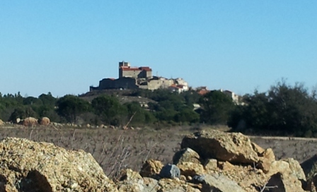
History: History of Montalba-le-château starts, as many other villages, at the prehistorical history. Between -2200 and -1800 at the megalithic times, that starts the construction of many dolmens everywhere in the region. Montalba has its own, still visible
Then it is the Ibéro-ligure then, the Celtic people arround -500, who occupied this region. Then came the Romans in -121 but did not leave any traces, neither the Wisigoths (408), their successors, nor the Sarrazins (739).
Origin of the village: No available documents can give us indication. The village took the name of its castle in the IXth century : It was built arround a big square tower. The chapel from the XIIth century, is still standing.
Montalba was belonging the the feudal lords of Perapertusa inthe XIIth century.
Territorial separation: Then came year 1258, with the merging of the families of the counts of Barcelona suzerain of Fenouillèdes, and the one of the king of Aragon, which imposes the clear frontier between France and Aragon. Then, the Fenouillèdes became French, as well as Peyrepertuse.
Of course, near the frontier, the castle of Montalba, was a location of multiple clashes between French ans Catalans.
Fortifications: the village has a polygonal fortified wall from the XIVth century, made of granite rubbles of 1.5m thickness. The castle has been rebuilt in different periods. It is in L shape, and the west aisle have been rebuilt in the XVI an XVII th century.
Source : https://www.les-pyrenees-orientales.com/Villages/MontalbaLeChateau.php
Campoussy :
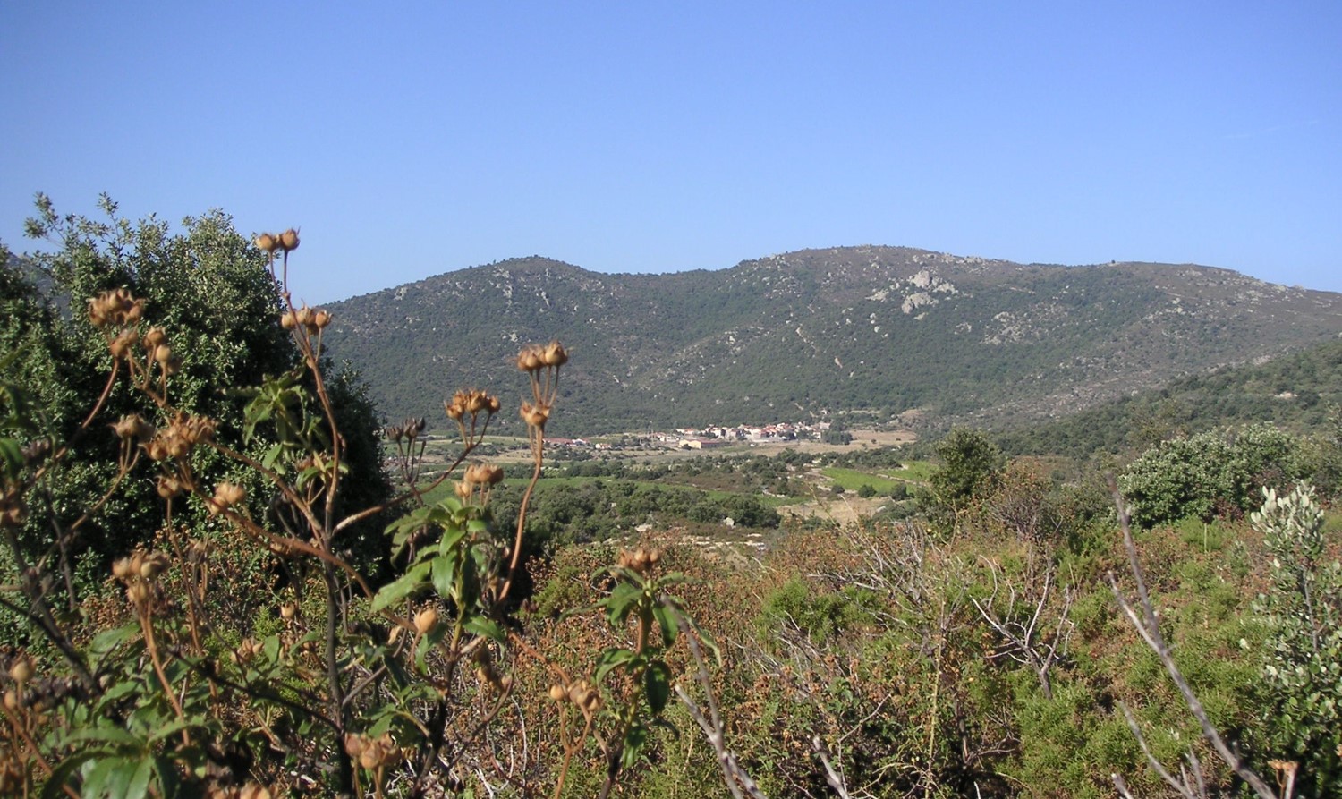
Situation : Campoussy is a small village in the Fenouillèdes region, in the South of Sournia. It is quite isolated, and the only road crossing it, is quite a deviation of the road between Sournia and Catllar, in the suburb of Prades. Sournia is at 4 km, and Catllar at 15 km. Sournia and Campoussy are located on the plateau of Fenouillèdes, that's explain why the road to, Catllar is long and sinuous, with quite an elevation : that's why it is well knowed from the cyclists of the department !
Some small paths are leaving Campoussy to other living places: Palmes, St Just chapel, Séquerre, etc... There is also the long Hiking Trail GR36.
Prehistory: At the older times, the region was inhabited by prehistorical men. Two dolmens remain: the one of Roc Cornut a few kilometers away from the village, in the direction of Prades, and the one of Mas Cayenne, much more difficult to reach.
Roman history: The Romans occupied all the region, and built a bridge over the local river. It is the only remain of this period.
History: We have to wait a few centuries to find some written traces. This first document is from the end of the first millenium, where it is mentionned "Campo Ursino" (Camp of the bear) and linked to St Michel of Cuxa. The castle was probably destroyed to build the Church, but was still existing between 1456 and 1476.
Patrimony, places to be visited:
St Etienne church: The Saint Etienne's Church was built in the XIIth century in a Roman style. Measuring 20m by 7m and 9m height, it could host 50 people.
In the XVIIIth century, the population increased from 150 to 600 people, so the church has to be increased. The works detroyed one side and increased the walls in a gothic style. Then in 1894 other works were done by adding two lateral chapels and a Baroque altarpiece.
Dolmens: Prehistorical history has left us two dolmens, near Campoussy. The first one is in the pass of Roquejalère, just near Roc Cornut (Pile of rocks). The second one is near mas Cayenne, but you need to go by feet, as there is no road.
Others: Campoussy has a simple oratory at the entrance of the village, coming from Sournia. The interest of the village is in the wellheads in good shape, situated inside the village, quite rare as, normally they are located outside the village.
Go to of environment présentation page
Source : https://www.les-pyrenees-orientales.com/Villages/Campoussy.php
Trévillach :
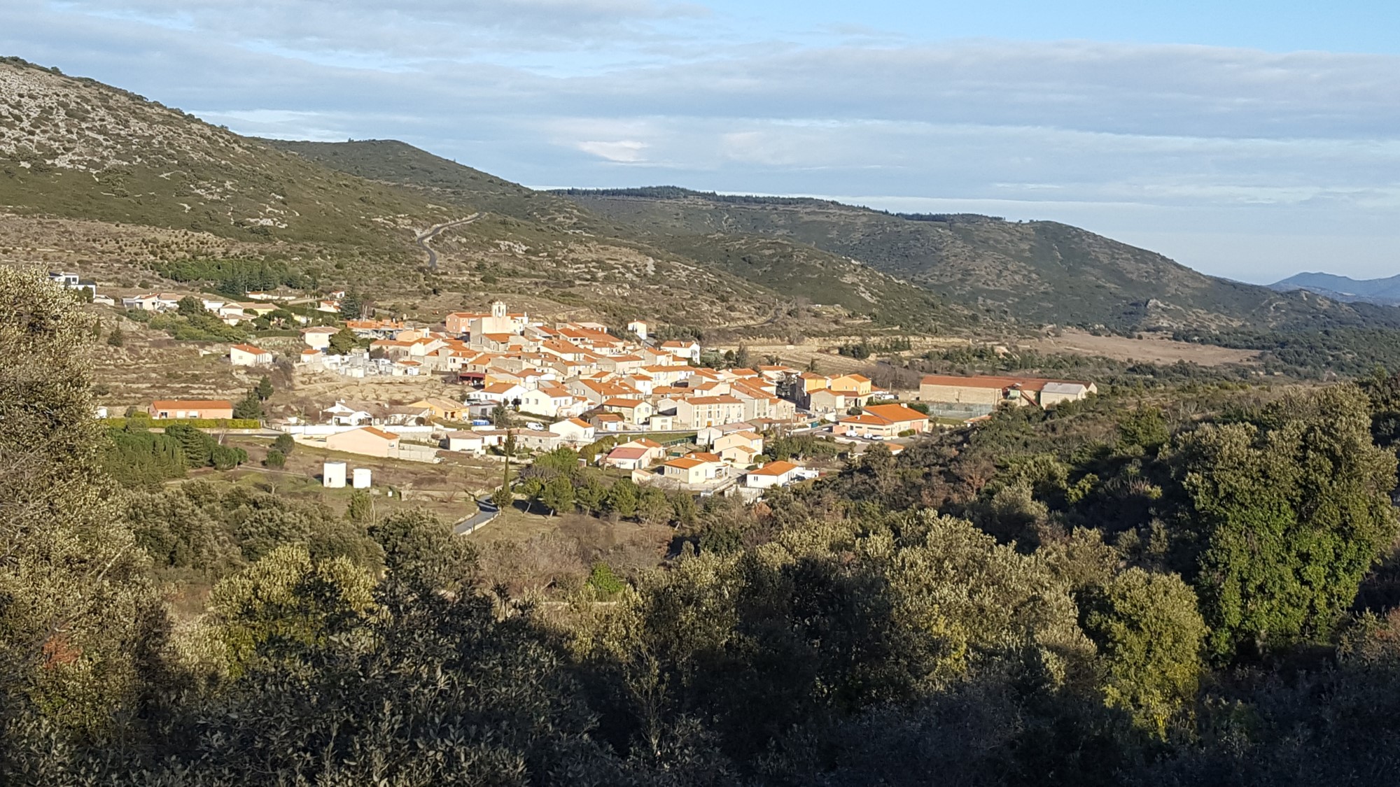
Trévillach is a village of 1724 hectares, located in Fenouillèdes, between llle-sur-Tet and Sournia.
Some paths are leaving the village, you can use them to go to some oratories at the beginning of ancien roads going to other villages. Of course the most remarquable site is the Séquère plateau, you can reach by car or by foot: Main access is on the road to Tarérach near the Auzine pass.
If you have the chance to go there without the tramontane (wind), you will be seduced by the landscape surrounding the rests of the chapel and the castel, and the fantastic panorama. The chapel dedicated to Saint Vincent, have been mentioned for the first time in 1011 in a papal bull addressed to Saint Michel of Cuxa abbaye. It was used as a sheep barn until the 70's.
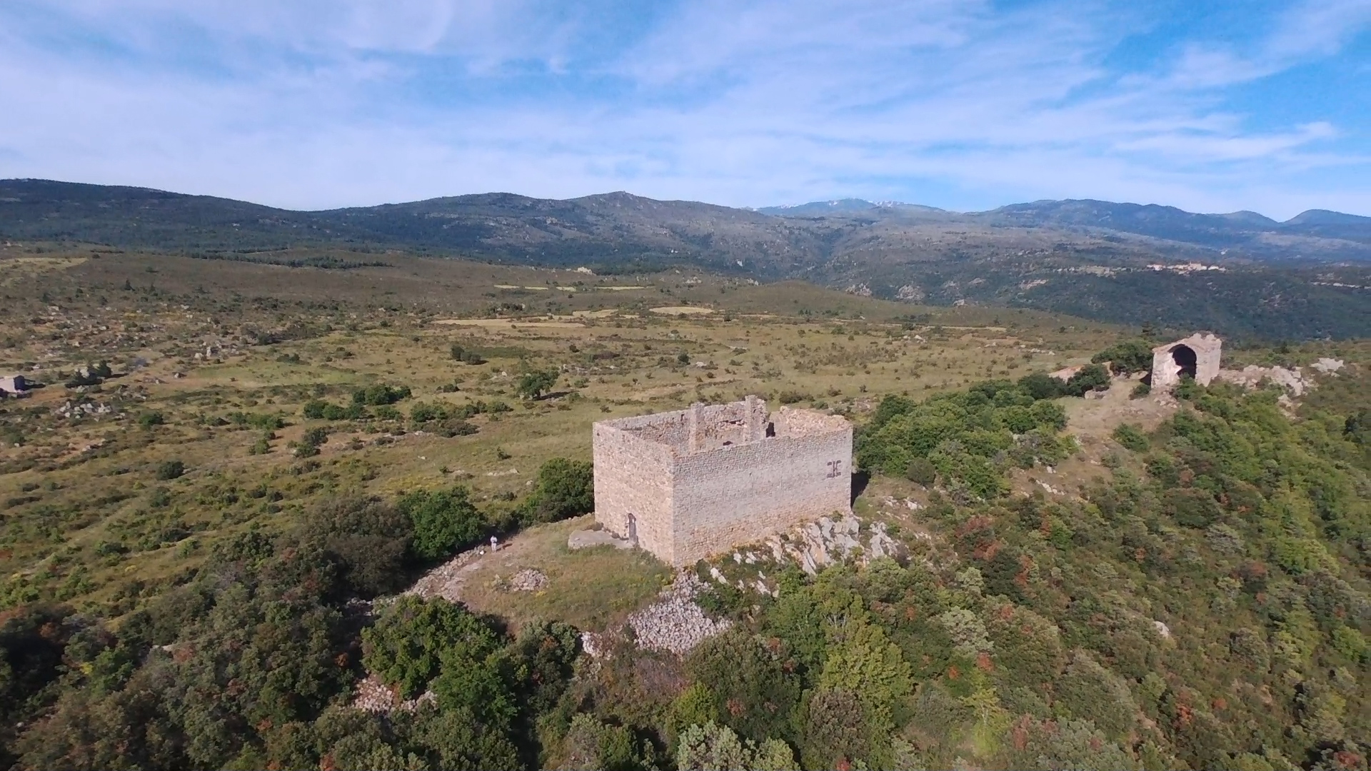
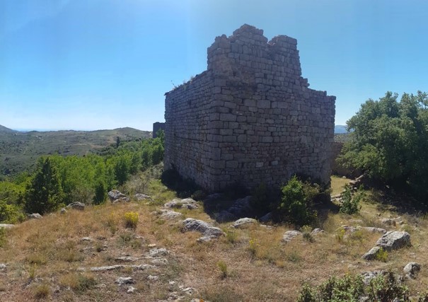
The castle, parallelepipeded rectangle of 13 meters by 20. Height of 10 meters approximately. The construction dates back to the end of the XII th century or beginning of the XIII th century. Inside the castle two strange pillars, named "demoiselles" by the inhabitants of Trévillach.
Other remarquable site is Roquevert, at the crossing of Sournia and Saint Paul de Fenouillet roads: In the middle ages it was a village, in which remain the rest of a castle and the windmill of Sainte-Marie. Please note also the beautiful road from Trévillach to Trilla, you can also reach by foot through Saint Jean pass.
Surrounding villages : Sournia, Prats-de-Sournia, Pézilla-de-Conflent, Trilla, Caramany, Montalba, Rodès, Tarerach, Campoussy.
The climate of the region is typically Mediteranean, slighly limited by the altitude, proximity of valleys and distance to the sea.
Plants are of Mediterranean type divided into three main types: garrigue, forest and vines
Go to of environment présentation page
Source: http://histoireduroussillon.free.fr/Villages/Histoire/Trevillach.php (In French)
Séquere plateau:
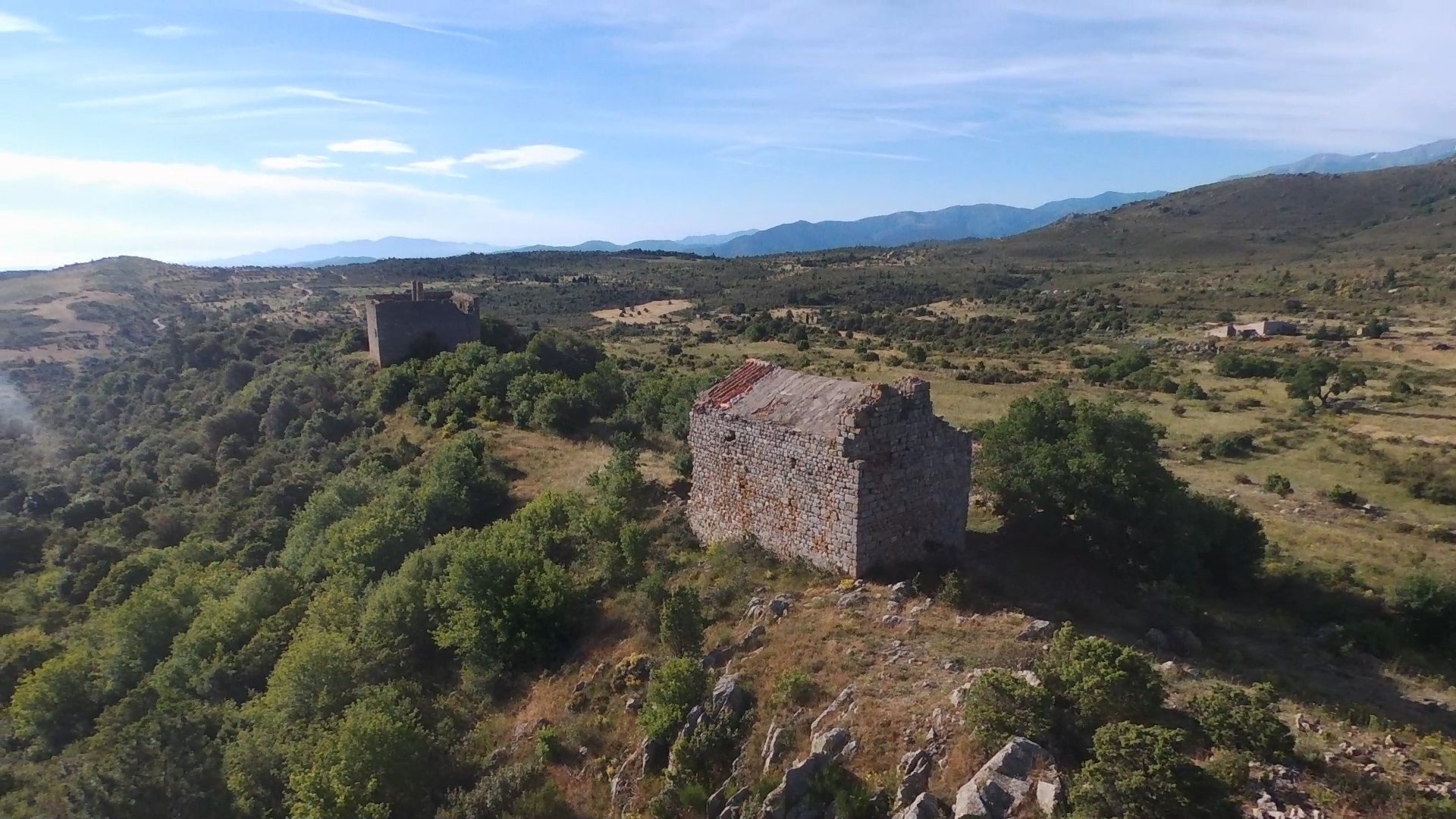
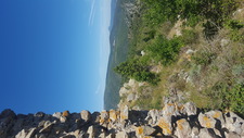
The old village of Séquere is situated in the village of Trévillach at 670 meters of altitude. resting on granite, it is positioned on one the peak of the plateau. On the west side, it dominates the valley of "col des Auzines" until the depatement of Aude, we can see also the Bugarach mountain. At the est side, Força Real is visible as well as the sea. South side we can see the Canigou mountain.
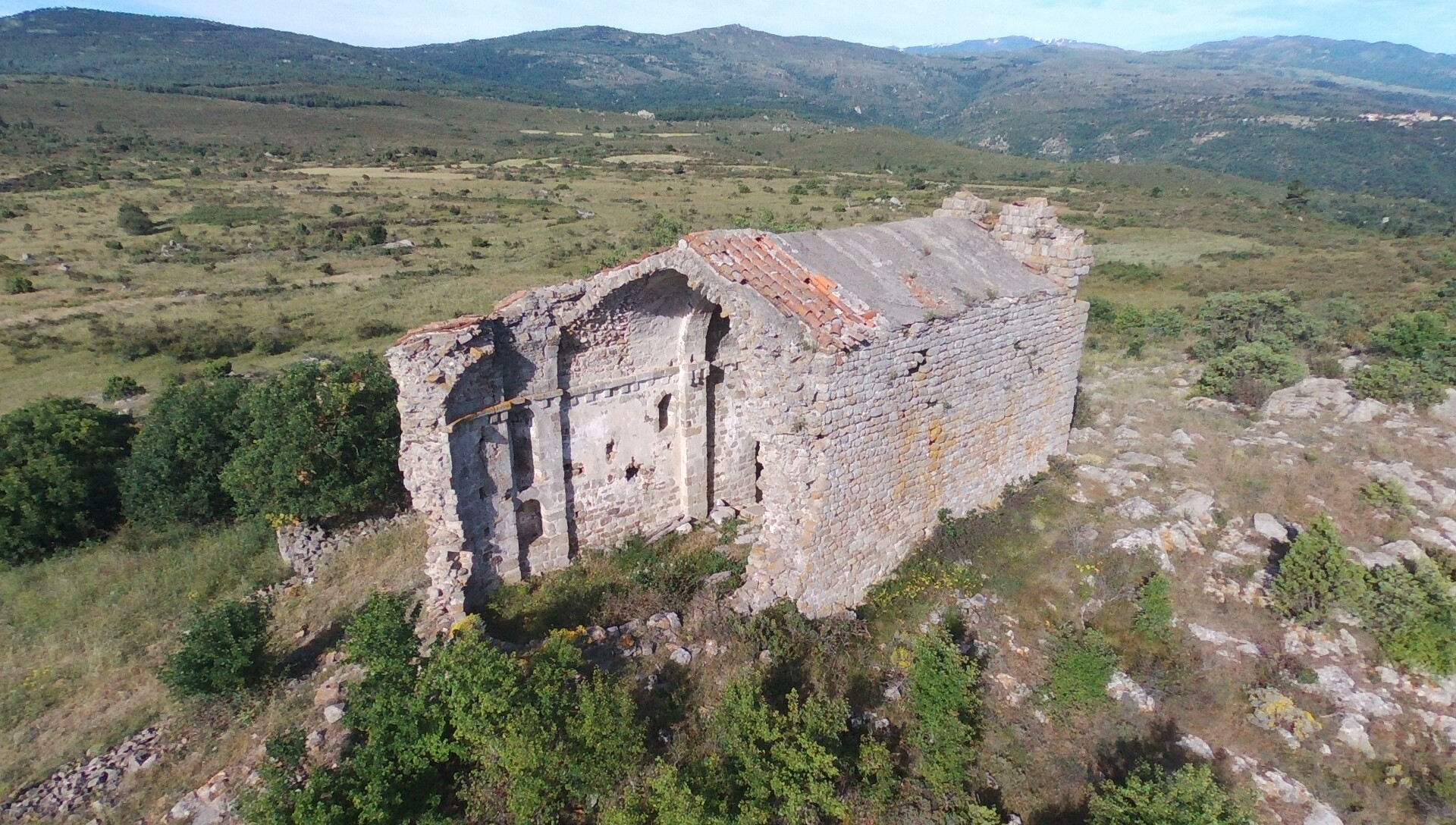
The only buildings remaining from this village is the ruins of the Saint Vincent's chapel, the sheepfold (probably the presbytery), the "castle" and in the South of these buidings some walls and foundations

Video of the plateau : click here (Please use subtitles.)
The Saint Vincent's chapel and its presbytery: The village of Séquère has been mentionned for the first time in 1011 in a papal bull addressed to Saint Michel of Cuxa abbaye. The plateau and the village are mentionned during XI, XII, XIII, XIV, XV th centuries. In 1410, Pere Punsich mentionned that Bernat Berenguer de Perapertusa is lord of Roquevert, Trévillach and Séquerre.
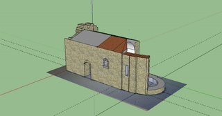
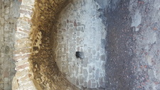
The chapel is made with one unique nave orientated est-west, 18,2 meters long, 7,2 meters wide. The west side has a platform, which was accessible before by a small staircase (stollen...). The entry is on the south side. Different elements of its architecture (blueprint, windows, roofing..) show that it is a roman chapel of the XIIth century.
Until the end the XXth century part of statues were visibles, the inhabitants of Trévillach have decided to move them in the cemetery where they have disapeared...
 |
 |
3D animation of the chapel in its actual state:
The chapel have been restorated th the late 70's, you can read some articles by clicking here (sorry in French)
It was a private property but the municipality is retreiving the ownership and give the management to the association via an an emphyteutic lease.
Inside the chapel as if you were there. Rq: depending on your browser (Internet Explorer or Android device) you may have display problem: In this case change browser, wait a few seconds to recharge the images or refresh the page)
The sheepfold (probably the presbytery) is a building of 8 x 10m on two levels, very close to the chapel. Private property, used as as sheepfold during many years, in poor state as well...
The castel : Fortified farm, parallelepipeded rectangle of 13 meters by 20. Height of 10 meters approximatly. The construction dates back to the end of the XII th century or beginning of the XIII th century. Inside the castel two stange pillars, named "demoiselles" by the inhabitants of Trévillach. It has been destroyed by Spanish companies during the Forteenth century.
 |
 |
Go to environment présentation page
Other photos of the site on this page.
Panorama west side of the chapel:
Panorama est side of the chapel:
To discover Séquere plateau:
- By foot: Park at the "col des Auzines" (D2 between Trévillach ans Sournia), then take the track nearly facing the parking. Allow one small hour waking without any difficulties. Avoid strong winds, hot or fog conditions. Chapel and castel are visible from the start, just follow the track
- By car: Take the D13 between Tarérach and Trévillach, the take the road on the right coming from Trévillach mentionned "Séquere". Continue during 2 kms approx, turn left before the house beneath the chapel, then right, then park and continue the 300 last meters by foot.
! BECAREFUL ! Do not leave anything, respect environment. The chapel is at a risk to collapse, it is fordidden to go inside.
- You are here:
-
Home

-
Catégories-English
- Environment